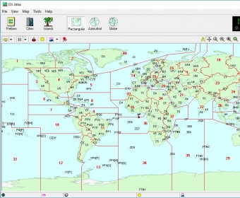
Electronic World atlas for Radio Amateurs. Scrollable World map with smooth zoom, DXCC territories, province/state prefixes, Grid Squares, CQ and ITU Zones in the rectangular, azimuthal and Globe projections, 3D relief, Gray Line, city and island index, unique hierarchical prefix database, local time with DST for all cities, islands and call areas, unique ionospheric maps.
Call area boundaries and prefixes are shown on the World map in addition to the DXCC boundaries and prefixes. Each prefix has a hint with a country and province name. Click on a prefix to find it in the Prefix Database.
CQ Zone and ITU Zone boundaries can be switched on and off. Move your mouse over the zone label to see the official definition of the zone.
The Maidenhead Locator map displays 2-character and 4-character grid squares. You can mark worked and confirmed squares and add comments to each square. The Grid Square calculator converts between the latitude/longitude and the grid square locator.
Rectangular, Azimuthal and Globe projections are available. The Azimuthal map center can be changed with a single mouse click to see how the World looks from a DX location.


Comments